The drive from Denver to Grand Junction, CO was the most spectacular yet. We saw a lot of variety in geography!
We started the day with a breakfast burrito.

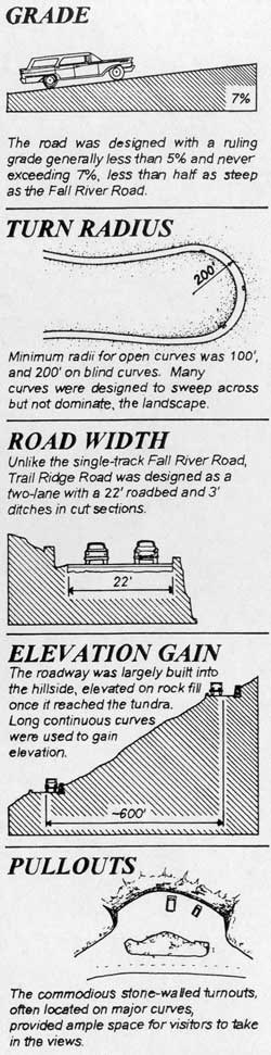
We tried unsuccessfully to get a last minute reservation to drive up Trail Ridge Road (U.S. 34) into Grand Lake, CO through Rocky Mountain National Park, where 11 miles of the highway are above the tree line (ends at roughly 11,500ft) and it winds along to a high point of 12, 183 feet.
However, the switchback turns up Hwy 40 over Berthoud Pass (11, 307ft) and Winter Park didn't disappoint. There were many pullouts along the way to take in the views at a slower pace, but there wasn't a moment that passed when we could not have snapped a postcard worthy photo.

The mighty Fit and Civic chugged up the Rockies and rolled into Grand Lake, sitting at an elevation of 8,369 ft. The town and lake (of the same name) is surrounded on three sides by Rocky Mountain National Park. Grand Lake is a Colorado's largest and deepest lake and is part of the headwaters of the Colorado River. There is a lovely historic, Western-style boardwalk in the town and we kept our eyes peeled for wildlife sightings. Sure enough, we saw a few deer right in town. Unfortunately, dogs are not allowed on trails in Rocky Mountain National Park (or in most national park trails for that matter) so we were not able to do a hike. We did find a lovely, uninhabited swimming spot to enjoy the glacial waters. We would definitely love to return here for a longer getaway!
After a refreshing dip, we headed back to town for lunch at the Sagebrush BBQ & Grill -- dog friendly picnic table dining of course -- and then for a short walk around the town's boardwalk.

After a walk around the boardwalk we traipsed back to our cars to begin our descent out of the Rockies.
 |
| Lake Granby looking toward Arapaho National Forest and Mt Acoma and Twin Peaks |
 |
| Hwy 40 Colorado River west of Hot Sulphur Springs |
 |
| Junction Butte/Kremmling Benchmark |
 |
Silverthorne, CO looking across the Blue River toward Buffalo Mountain and Red Peak |
 |
| I-70 White National Forest & Colorado River |


 |
| Palisade, CO mesa and cliffs |
As the Colorado Rocky Mountains petered out (sadly), we entered Palisade which is named for the cliffs near the town. Palisade is known for its peach orchards and wine vineyards. The climate, a 182-day growing season, and an average 78 percent of sunshine makes it "The Peach Capital of Colorado". The region is called Mesa County, named for its characteristic mesas -- wide, flat-topped elevated landforms with steep sides. Mesa is the Spanish word for table. Spanish explores of the American southwest, where many mesas are found, used the word because the tops of mesas look like the tops of tables. Mesas are formed by erosion, when water washes smaller and softer types of rocks away from the top of the hill. The strong, durable rock that remains on top of a mesa is called caprock. A mesa is usually wider than it is tall.
We slept in Grand Junction, CO (just a bit further west from Palisade), near the Utah border.
Day 5: ~ 550km


 After a walk around the boardwalk we traipsed back to our cars to begin our descent out of the Rockies.


The trusty Fit does it again!
ReplyDeleteSo fantastic! I missed out on so much not being able to go on this journey with you! 😭🥳
ReplyDelete